
I can’t believe that I started my day by landing in Reykjavik at 6:30 in the morning, and I have already seen and learned so much about Iceland (with more geologic knowledge to come!).
Myself and 12 additional colleagues (mostly from California, Washington, and Minnesota) are a part of this course in “Exploring Iceland’s Physical Geography and Geomorphology.” Our leader, Jim Wysong, was wise in having our first day together be one where we get to know each other and get to know more about Reykjavik and the local culture.
To provide my students with some random Icelandic information… It was Vikings from Norway that first settled Iceland sometime between 870-940AD. Today, Iceland has ~322,000 people living in the country, with 75% of that population in and around the capital city of Reykjavik. The Icelandic mainland is approximately the same size as the state of Pennsylvania, with 70 golf courses (a popular and cheap sport in the country) and seven swimming pools (six are outdoors). Geologically, there is some disagreement as to how the island formed… and we’ll get in to that later in the week!
Our first stop of the day – Hallgrimskirkja Church. This is the National Church. Its external and internal architectural style is Gothic yet resembles the volcanic feature columnar basalt. In front of the church is a statue of Leif Ericson, the Norse explorer regarded as the first European to land in North America in the 1440’s (yes, that is before Christopher Columbus). This 6th-largest architectural structure in Iceland that took 38 years to build also has a pipe organ with over 5,000 pipes!

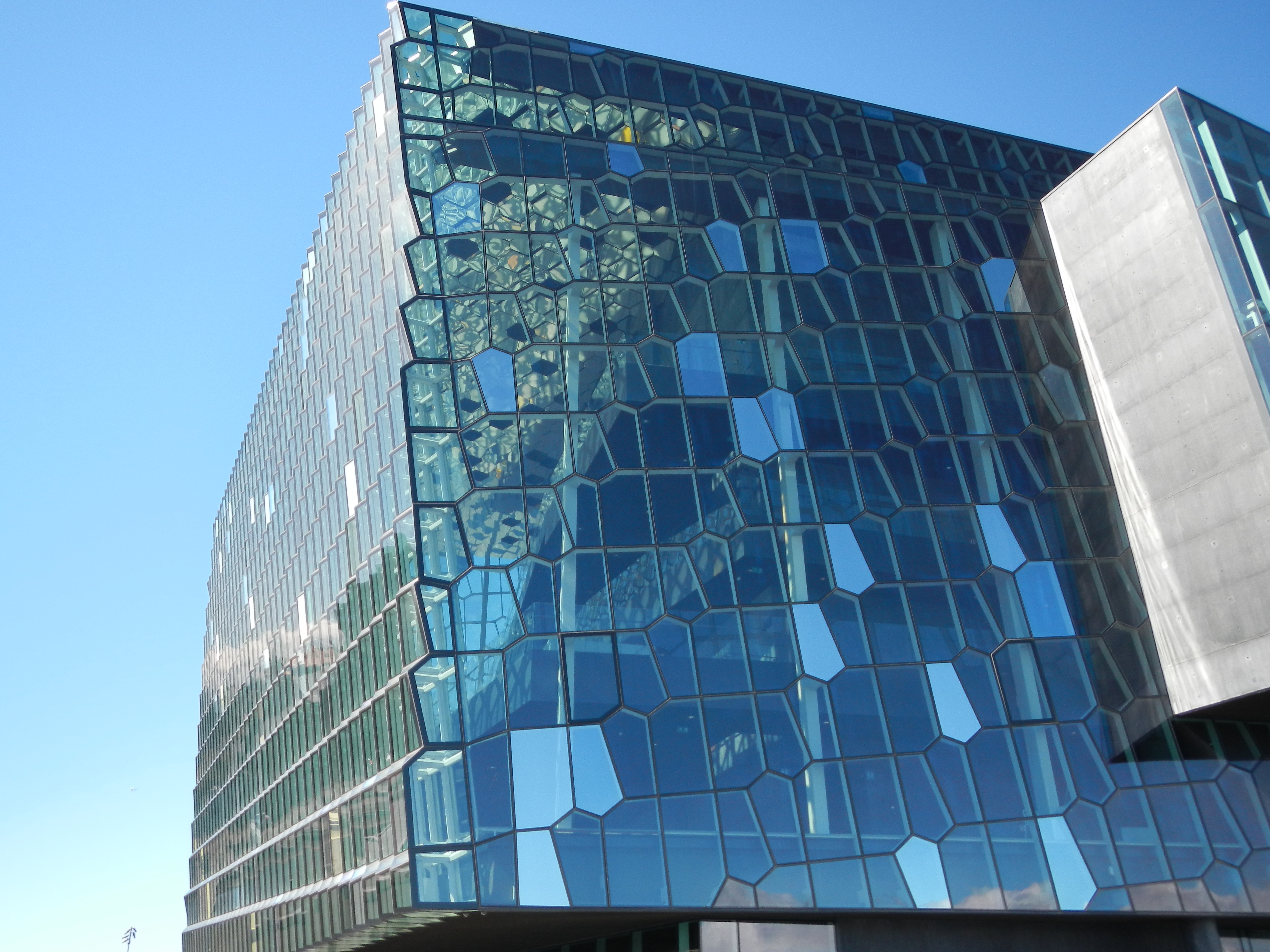
Next stop – Harpa Concert Hall. This site is an excellent example of new and modern design in a much older waterfront. Docked next to an Icelandic Coast Guard ship is this two-year old concert hall and conference center. The steel framework holds geometric-shaped glass panels, some of different colors to create an amazing effect on the inside when light shines through. Absolutely stunning!
Next stop – A walk from the Concert Hall to City Hall. Reykjavik’s City Hall has an amazing 3D topographic map of the island that really helps a new visitor visualize the physical geography of the island. Unfortunately, when we arrived at City Hall, one of the workers was putting away the map to get set up for a special event. I wasn’t able to get a good photo or spend enough time looking at this map, but the quick look we did get certainly helps me frame what we will be seeing this week.

Next stop – Perlan. Perlan, or “The Pearl,” is an interesting structure. It is four hot water storage tanks that had a restaurant and 360-degree observation deck constructed on top of the tanks. The view are quite impressive. One of the tanks no longer stores water but now houses the Icelandic Saga Museum.

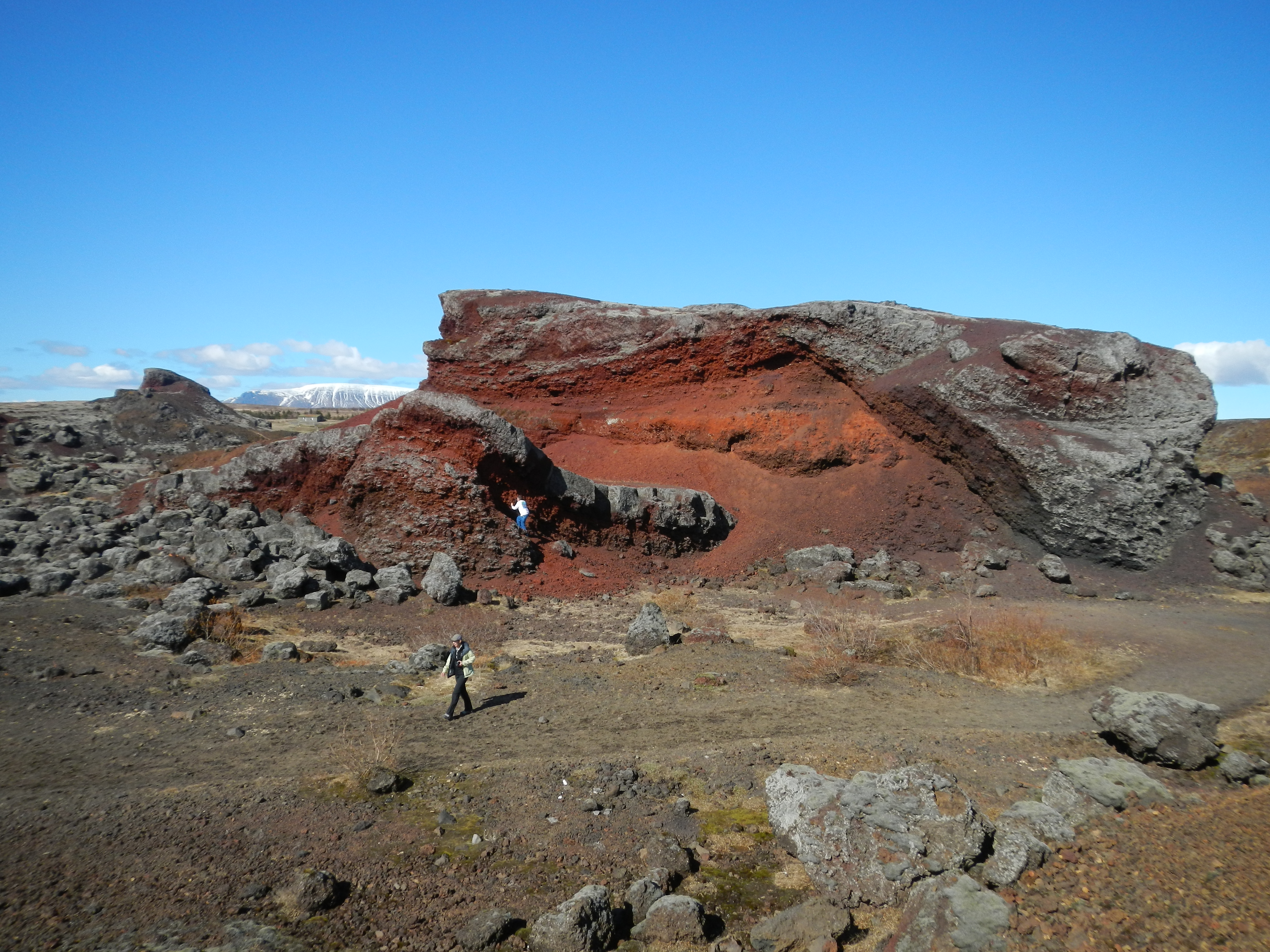
Final stop – Rauðhólar Pseudocraters. Now we start exploring some really interesting geology! OK, here’s the background…. The Leitahraun Lava flowed from a shield volcano through this area approximately 5,200 years ago. The extremely hot lava transferred its heat to the ground it was flowing over. In this region, the water table is high. The shallow water heated, generated steam, and then caused explosions through the cooling/cooled lava that left depressions in the ground resembling craters. The different heat levels from the super-heated water and steam caused different oxidation states to occur, causing the iron to change to different shades of red. I can’t imagine how loud and large these explosions must have been to generate over 80 craters! But the city put the materials to good use, using the loose gravel-sized material, especially during World War II, for construction projects such as Reykjavik Airport and road construction. The mining of the craters is what has helped expose the inside of these features for study. Because all of this scoria (vesicular basalt) is now a protected park, we could not collect any samples to bring home. 😦
I have lots and lots of photos from this site! I’m sensing a classroom lecture in the future…
Tomorrow will include a visit to a geothermal power plant, geyser/hydrothermal field, waterfall, rift valley, and volcanic crater lake. Can’t wait!
